Cartographer
Forestry Commission
Simon D
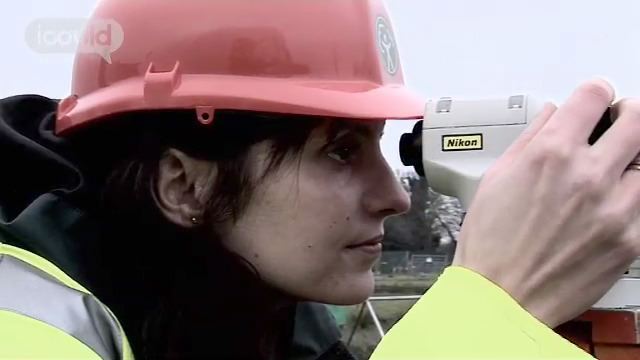
0:00:02 My name is Simon D and I work as a cartographer in the Forestry Commission. The job involves creating a range of sort of spacial data and maps which we provide to the rest of the Forestry Commission. A lot of our work is creating sort of the data or maintaining the data so we wouldn’t necessarily actually produce a lot of maps on paper so to speak. A lot of it would be held in sort of data sets. These are a few examples of some of the work that I’ve been working on recently. This one is an area for a habitat survey and this is a layout sort of design for them to be able to take out with them in the field and use it for their survey. This one here is an example of a soil survey area and these different colours on the map basically indicate the different soil types.
00:00:59 I suppose I was interested in sort of science subjects mainly. At one point I was sort of interested in meteorology, or sort of forensic science stuff. I did geography for sort of GCSE level but I didn’t do it at A level, but I’ve always sort of had the interest in the sort of more sort of physical side of geography rather than the sort of urban side or the humanity side of it. For A levels I did maths, physics and business studies. When it came to choosing my degree, I sort of wanted to choose something that was a bit more practical.
00:01:33 I chose a subject called geophysics which I did at Leicester University. Geophysics is exploring the structure of the earth, so it’s like sort of an earth science subject. So it involves sort of doing a lot of field work to measure the sort of resistance of the earth below. I enjoyed parts of the course in geophysics and not so much other parts of the course. I enjoyed creating sort of models from the data we’d collected, so creating sort of 2D or 3D models. There was also a large part to do with maps. We went out and did sort of geological mapping surveys which I quite enjoyed. That’s sort of how it got round to sort of thinking about working with maps.
00:02:21 Well I started not in the Forestry Commission. I started working for DEFRA, so the Department of the Environment for Farming and Rural Affairs, and it was kind of by accident in a way because I was trying to decide what to after I’d finished and I saw an advert in the paper for a cartographer and I thought, ‘yes, this would be something I’d really enjoy’. And I really sort of learned a lot of the cartography on the job, because a lot of it wasn’t…was new to me. I think the best thing really is the sort of visual aspect of the work. It’s being able to take a lot of information, a lot of data in different forms and be able to turn it into a visual product like a map.
00:03:02 I think I would like to develop my job in a sort of more sort of pushing the boundaries of the use of cartography and GIS and really sort of, sort of expand the use of it really because I think it has enormous potential benefits to pretty much any organisation in terms of their sort of planning, decision making and efficiency of their business.
ENDS
Simon D is a Cartographer with the Forestry Commission. He studied Geophysics “I enjoyed creating sort of models from the data we’d collected, so creating sort of 2D or 3D models. We went out and did geological mapping surveys which I quite enjoyed… I would like to develop my job pushing the boundaries of the use of cartography and GIS”.
More information about Conservation and environmental associate professionals
The UK average salary is £29,813
There are 37.5 hours in the average working week
The UK workforce is 47% female and 53% male
Future employment
- Assists with ecological surveys to identify plant and animal species, map their habitat and draw up conservation plans;
- Implements schemes for the management and protection of natural habitats;
- Assists with environmental audits and impact assessments;
- Organises and supervises conservation projects and the work of part-time and voluntary staff;
- Provides information and education to the public through setting up displays, writing leaflets and making presentations;
- Organises guided walks and answers questions from the public about an area and its wildlife;
- Works with the emergency services in instances of fire, flood, injury or mountain rescue.